Weird Wonders of the American West

Our nation’s Western region boasts a spectacular array of vistas, from icy-blue glaciers that glitter in the sun to ethereal deserts that extend as far as the eye can see.
Some of its most breathtaking spots have even gained worldwide fame, including the Grand Canyon and Yellowstone National Park.
But there’s more out there to take in than these typical landmarks. If you’re looking to fill your photo album with more extraordinary sights, seek out a few less conventional selections: quirky and downright strange scenes dotted across the varied patchwork of US geology. Here are four oddities where you’ll find Mother Nature’s creativity on full display—and be inspired to see what else the American West has to offer.
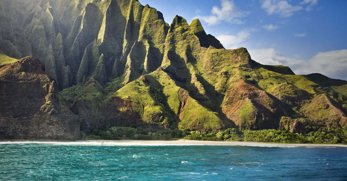
Waimea Canyon, Hawaii
With all this lush state’s awe-inspiring qualities, from jewel-toned waves to vibrant palm beaches, some of its more obscure sites may go unnoticed. Take “the Grand Canyon of the Pacific,” located on the island of Kauai. Here, a more than 3,000-foot-deep chasm surrounded by tropical trees conceals the mystifying Waimea River, which flows red through the over ten-mile-long canyon amid rugged crags and rushing waterfalls.
As grisly as it may sound, though, the river actually gets its color from the vibrant sediment of the surrounding walls, which is deposited by erosion. If you’re active and healthy, admire the waters up close via a jagged hike down Kukui Trail to the canyon floor. Or stick to the Iliau Nature Loop Trail at the top of the ridge for panoramic views of the rock formations and tropical forest—you may even see a rainbow crossing the expanse for an additional splash of enchanting color.
Another option is to take a car ride up Waimea Canyon Drive onto Kokee Road, a route that snakes through the park along the west side of the expanse and features abundant scenic viewpoints. And don’t leave without trekking to Waipoo Falls, an 800-foot spectacle that pours into the rosy canyon below. Just be sure to bring an umbrella since this is considered one of the rainiest places on earth.
Tracy Arm Fjord, Alaska
Like Hawaii, our northernmost state is absolutely brimming with marvels, but this glacial setting may be one of its lesser-known quirks of creation. Technically a fjord, or narrow inlet of water between tall cliffs, Tracy Arm is notable for its 1,000-foot waterfalls and perennially snow-capped mountains—in fact, this remote region can see more than one hundred feet of snow annually!
Perhaps the most astounding tourist draws, however, are the ice formations, including the Sawyer Glaciers: tremendous forms that extend from deep underwater, giving them an extraordinary sapphire-blue color. They are also ever-changing; visitors often describe hearing an echoing crash as they witness giant ice mounds tumbling into the waters below, which then flow downstream among a litter of other enormous ice shards.
You can locate Tracy Arm Fjord just forty-five miles south of the state’s capital, Juneau. This unforgiving landscape is only accessible by boat or plane, making it virtually necessary to book a guided tour. But it’s well worth the investment to access what naturalist John Muir once referred to as “a wild, unfinished Yosemite.”
Badwater Basin, California
At 282 feet below sea level, this California peculiarity earns the designation of the lowest point on the continent. The stark-white expanse within Death Valley National Park is actually the remains of an ancient lake that dried up to reveal salt flats, or grounds rich in minerals like sodium chloride (the chemical we know as table salt), which have formed into crystalized, cracked slabs that rise from the sandy floor and sparkle in the sun. As for the former lake’s disappearance, blame it on Badwater Basin’s extreme evaporation rate of 150 inches annually, meaning that a twelve-foot-deep, thirty-mile-long lake would dry up in just one year.
Oddly enough, though, some wildlife in the area, including unique plants and snails, has evolved to tolerate the high salinity and heat of this landscape. Unfortunately, the same can’t be said for humans, so if you’re planning a visit here, book an offseason trip in late fall or winter and take an early morning excursion. You can view the strange scene from the comfort of your car or along the Badwater Basin Salt Flats Trail, featuring a convenient boardwalk as well as a quick, immersive hike across the lake’s remains. No matter which path you choose, visiting this desert is an experience you surely won’t forget.
Great Sand Dunes, Colorado
High in the Rocky Mountain range sit some of America’s loftier peaks—and, strangely, its tallest sand dunes. That’s right, our greatest sandy pinnacles are flanked by snowy mountains in rugged Colorado, reaching heights up to 741 feet. But how did Mother Nature build a desert here? Ironically, the answer is not a lack of moisture but a direct consequence of it. As nearby rivers and creeks carried sediment and sand downstream, the deposits settled in this deep, bowl-like valley. Storm winds from the surrounding summits then eventually shaped the Great Sand Dunes we see today. These weather conditions make this miniature desert shift and change all the time, so each visitor is guaranteed a unique experience.
Surprisingly, there are no trails across the thirty-square-mile dune field, allowing you to wander the area at your leisure. You might even spot some visitors “sandboarding” across the waves—or grab a sled and give it a go yourself! And if you’re looking to get your heart pumping, you can hike up any of the many dunes for spectacular views from the top (an arduous yet satisfying hours-long trek) or along a shaded forest trail to escape the sun. Whatever your adventure of choice, make sure to stay after dark on a clear night for unbelievable stargazing as spectacular as the terrestrial scene at your feet.
24 Views